**At 5 seconds, I drop the F-bomb*** The video is otherwise clean. Sorry about that!
On October 27th, 2024 I observed a strange looking aircraft flying low off to the side of my house. I checked FlightRadar24 and there was no sign of the aircraft, which told me that its transponder was off.
I sat outside and had my camera ready; I was able to capture a very clear image of it during the third pass directly over my home. The registration number was clear as day on the underbelly (C-GCFZ).
I discovered it was registered to this corporation: Terraquest, Ltd out of Canada.
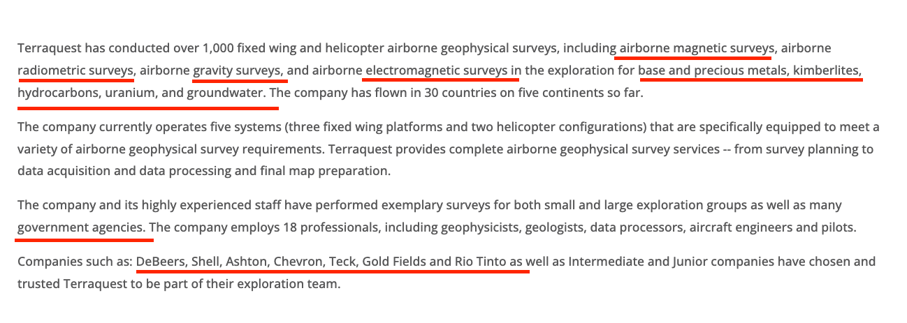
I looked them up, and felt a bit alarmed by the surveys they have performed for some pretty prominent companies. Rio Tinto? Shell? Chevron? Gold Fields? DeBeers? What was this plane looking for? More gold?
I immediately called and left a voicemail for Operations. I have a few concerns, noted near the end of this post.
The following evening, I received a phone call and spoke to one of the owners, Charles Barrie. He was an incredibly friendly man, and willing to share a lot of information (we talked about the carbon capture scam, Dynamic Aviation, and crop dusters working “under the table.” Very enlightening.
That aside, regarding the work he was doing over my home and in California:
He told me that his company, Terraquest, was hired by California State and the Department of Conservation to do some geological surveys.
”Terraquest provides complete airborne geophysical survey services -- from survey planning to data acquisition and data processing and final map preparation.”
How the government will use this data is unknown. Terraquest is only responsible for taking the aerial surveys and handing over the data.
He referred me to the Department of Conservation in California to see the various maps & data collection they may be doing. Here is a snippet of what I found:
I personally have concerns for how this data might be used with regard to mapping precious minerals, water, and for land use, agriculture, oil & gas, etc. Frankly, I don’t trust our state to do what is best for the people.
As I believe “the Great Take” is upon us, I will wait to see how California intends to use the data in the future.
Not to digress too much, but I’m going to go there:
I’m a bit leery of how much surveillance and data is being collected. One reason I’m more hyper-aware of surveillance is because Tuolumne county has built two Rockefeller-funded Resilience Centers in the past two years I’ve lived here.
I can’t help but wonder if some “insiders” might be expecting a catastrophic event out here. Call me paranoid…but I don’t trust funding with strings attached from the billionaire class, especially from the Rockefeller family.
Learn more about the Rockefeller Resilience Centers and FEMA camps here. In the clip (6 minutes in), BardsFM details the One Billion Resilient by 2030 and he kindly played a clip from a another video I made two years ago.
FEMA went on to occupy our Tuolumne Community Resilience Center after some flooding (which I believe was directly linked to the heavy cloud-seeding that winter). We had a tornado and flood alerts, to boot.
Anyhoo. Time will tell. Not a bad idea to always be prepared with gas, food, and a bug-out bag. :) Home defense doesn’t hurt, either.
UPDATE:
I received a call back and spoke to a lovely man named Jeff from the CA Department of Conservation.
Essentially, he confirmed that they're looking for geological features for the region. They're looking for magnetic data to detect various fault structures & other structures AND they're looking for exposed igneous rock to identify different minerals deposits for critical minerals in the ground. He mentioned a couple of projects looking for critical minerals….to help us meet our clean energy goals. HMM.
OF course, there are CRITICAL minerals like cobalt, lithium, nickel that can be used for clean energy. :) WINK!
I asked where the funding comes from:
California is paying for this data to be collected and plugged into 3D modeling. The data will belong to the state; when I asked if they would provide the data to the general public, he said they have a duty to provide data to the general public. I asked when it will be available, and he's not sure.
This aerial survey is a new project with exclusive funding coming from the Governors's budget: taxpayer funds and special fees. He did not have the cost of this particular contract.
He mentioned that CA Senate Bill 905 was key to this particular project.
Title: SB 905, Caballero. Carbon sequestration: Carbon Capture, Removal, Utilization, and Storage Program.
I have submitted a PRA request, and received a notice on November 25th that it had been received.
Two individuals shared some information with me:
”I just talked to the guys that are flying it, they’re from Canada. They work for some Chinese firm top-secret shit they couldn’t tell me anything.”
and
”The pilot was Canadian (didn’t get the company name) and said the Chinese were paying them to look for gold. He promptly said after that, he shouldn’t be saying that. The little stinger on the plane is a deep penetrating radar apparently.”
FOLKS. Eyes open!
Stay curious and observant, ask questions, and DOCUMENT!
Update: December 9th, 2024: I received the contract between Terraquest and the CA Department of Conservation. Here is the PDF.
You can download the 23 page document here:
Note the dates for this contract:
I have followed up to ask them to explain why this aircraft was flying in October and November of 2024, and to let me know if they have any restrictions on how this data can be shared or sold to foreign or domestic NGOs or corporations.
To be continued.


Share this post